


Rotterdam 2050
Masterplan
Typologie: Urban design, Landscape architecture
Location: Rotterdam north, NL
Design team: Georgia Gkratsou, Hei Yi Joyce Fong, Lok Yan Minnie Chu, Matthijs Johannes Hollanders, Rohaan Teli & Sun Woo Cassy Kim
Published: Atlantis Magazine 29.4 Emerging Appropriations, 2019, Polis, p48-49.
The city center of Rotterdam is blooming allready, but other parts of the city still have lots of opportunities to increase the liveability. The northern part of Rotterdam has several issues to solve in the coming decades; fresh water shortage, inland flooding, excess infrastructure facilities and the demand for more housing, providing land competition between the ‘green’ and the ‘built’. Besides that, Rotterdam The Hague Airport creates a thick boundary between the city and the polderlandscape of Schieveen.

Green and blue vision
All these problems are addressed in the green and blue vision for Rotterdam. The Rotte river and the Schie canal are improved to establish recreational lines from north to south, while new east-west connections are introduced in the norhern part of Rotterdam. Another route allows easy movement from the city center of Rotterdam to the newly introduced residential areas, which is necessary to include them in the cities metabolisms. A clear city boundary ensures the preservation of the unbuilt land which is used for recreational purposes. To solve the pressing waterproblems, different compartments are introduced in this polderlandscape, each based on its elevation. Several agricultural fields and forests are kept, but lower areas could be used for wetland agriculture, wetland nature reserves and even lake communities. The urban side of the boundary is in high need of housing, but without the ability of expanding, the answer to this challenge is densification.


Urban structures
Introducing structures which cover large areas ensures the city to function as one organism. Watermanagement is most important in the Dutch delta area inwhich Rotterdam is situated. All rivers, canals, lakes and ditches are regulated so the land on which we live remains dry. By pumping the land dry, the land sinks deeper. A bad combination with the change of climate in which we have to deal with extreme drought, extreme rainfall and a rising sealevel. Therefore a new waterstructure must be formed in which water can be stored in times of surplus water. This water can be used in times of scarcity.
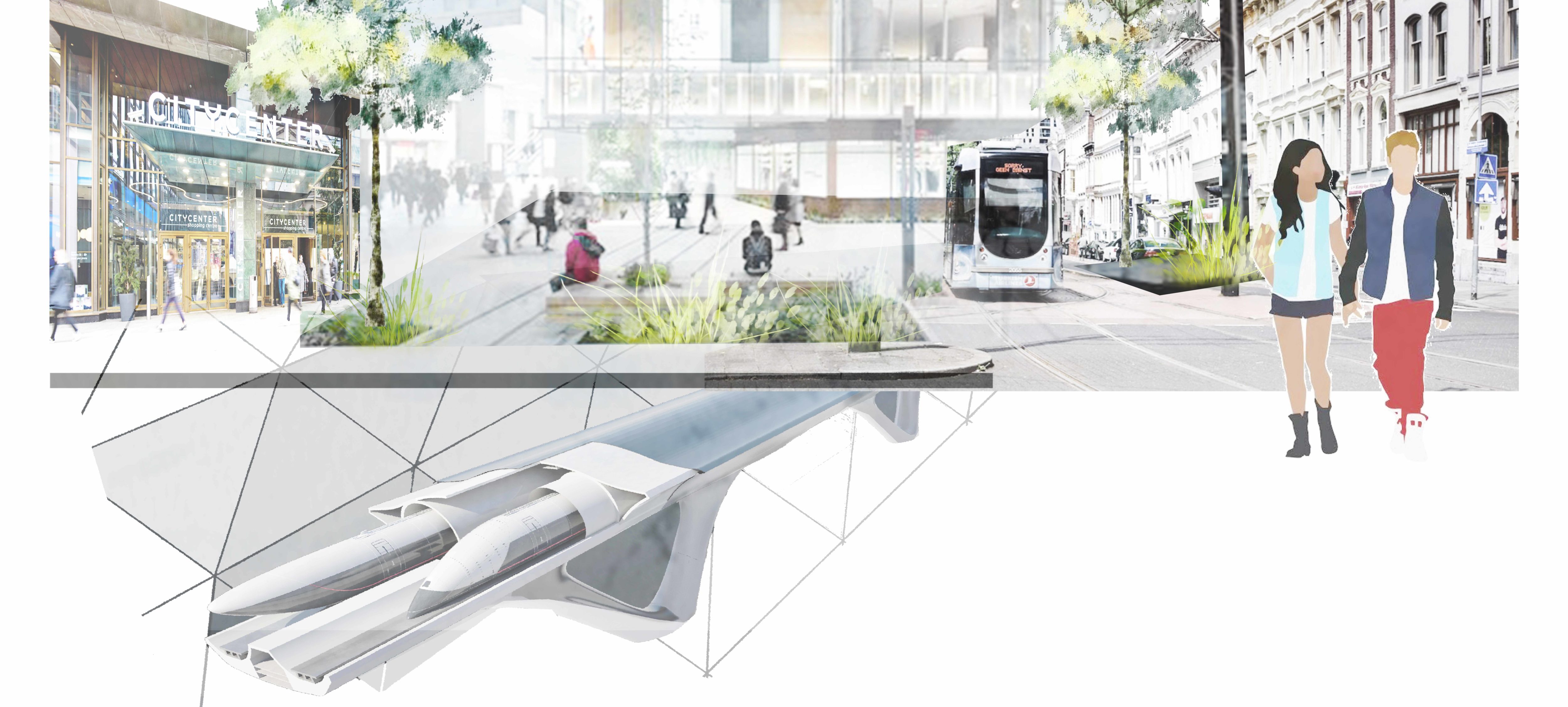
The green structures of parks and lanes should be linked together. By gluing these fragments together, not only an urban recreational system is made, but also an ecological web for other species. In the newly built areas, mobility must focus on new ways of transportation. Slow traffic matches the recreational system, while public transport should replace car ownership.

Densification
In Rotterdam, expanding is no option, which means the city needs to densify in order to meet the cities demand for more housing. Schiebroek is one of the selected neighborhoods for densification. This does not only mean the addition of housing, but these changes should go hand in hand with improvements considering the public space.
Besides densification, some areas could be transformed. Industry will move out of the city which clears the edges of the Schie canal, allowing the development of large building blocks along the water. This includes the development of the recreational routing alongs the water edge.
The lake communities are part of the proposed new developments of residential areas. One of these communities is replacing the airport which is transformed into a big waterbody on which floating communities thrive. They are used as a source for fresh water and to solve the problems of inland flooding by connecting to the watersystem of the surrounding neighborhoods. This area is located in one of the lowest areas of Rotterdam; ideal for a water based landscape. The lake will serve as a buffer in both wet and dry periods throughout the year.


PHASING
The proposed changes are spread out over more than three decades, not only because of the expenses and the size, but some changes need to develop over time. The lake will be dug out and the soil can be used to heighten the land and build the dike which protects the allready existing neighborhoods. A pattern of waterways and ditches need to be made to allow movement to and from the lake. After the lake is filled with water, the wetland nature area can be developed now that the recreational entrances are made. The infrastructure changes, moving the main car movement to the north (N209) and transforming the A20 into a new mobility vein, replacing the highway and offering an alternative for travelling by airplane.

Lakeside view
The new built housing community is connected to the city center to make movements in both directions possible. The new lake contains several functions: waterstorage, a fresh water basin underneath a lakeside market, ecology, housing, recreation and farming. The value of a lake is the wide view over acros the water. To make sure this quality remains visible for both residents and recreational users, studies need to be done to include every single user.
The building masses are placed in a way, allowing space for visitors to enjoy the natural look of the area. Along the lake, these buildings are three to four stories high and less wide than the buildings behind the lake route. Birds can find their place on islands, placed in the middle of the lake, on the former landing strip of the airport.

Public and private
The lakeside route meant for recreation of all citizens of Rotterdam, but the area should also contain spaces for the local residents. Therefore, a peacefull inner world is made in between buildings. Small streams penetrate the area, allowing smaller animals and insects to exist. Some buildings could contain a greenhouse connected to the surrounding landscape, allowing a large variety of plants to flourish. Residents can choose to enjoy the pleasures and activities of the lake or to enjoy the calm and green courtyard landscape. People living on the lake will have open view over the water.


HARVEST
The water is the source of life in the neighborhood. It provides a landscape for recreation and ecological developments, but it can also be used to introduce 'aquafarming'. Floating greenhouses can use the water directly from the lake to feed the people living there. Mussel cultivation might be an opportunity to use the area to the full. All houses should be self sustaining and in no need of a sewage system. Therefore, they are connected to helofyte filters which can be harvested as compost. Roots of the aquacultures, together with the planting along the lakeside make sure the waterquality remains in good condition.
